Pages

Monday, May 7, 2012

A Little Insight to Community based GIS applications.


We live at a time when information is a vital commodity. But the value of any information is determined by timeliness, accessibility, and by our ability to understand and use it. Internet has become a remarkable platform which empowers people, by satisfying any kind of information need on user demand. Spatial data has become one such highly demanding information need and internet provides a unique platform to distribute them. The growth of the internet and increasing demand for geospatial data in various social streams, have lead the way to popular Geographic Information Systems to appear over the past decade.
Geographic Information Systems (GIS) are designed to capture, store, manage and present geographical information to assist the users in making better decisions. GIS integrates geospatial services in the cloud bringing together real-time data and user-generated content from mobile devices, applications and social networks. These solutions can support a wide-array of specialized applications for various vertical markets, including public safety, defense, transportation, natural resource management and agriculture, as well as more common needs such as geo-location identification to support CRM and asset management applications, or navigation and global positioning for transport and supply chain management. Participatory GIS (PGIS) is one of the recent trends where the community drives in to. There internet plays a major role, allowing the developers to share, maintain and disseminate the data and give the possibility to expand participatory opportunities to interested parties.
One such application is  foursquare which is a mobile and web application, that allows its registered users to post their location at a venue and connect with friends. This will be appeared as a “check in” and it needs active user selection. Each check in will be awarded with points and users can choose to post them on Facebook or twitter or on both of them. When a user checked into various places, foursquare will offer badges also. Foursquare comes with three user levels to rank the registered users on their contribution to the community.

  • Super user level 1 can edit venue info (name, address, cross street, phone, Twitter names, and map pin location), mark venues as open or closed, request venue merges and deletions, and edit venue tags.
  •  Super user level 2 can additionally merge duplicate venue listings, adjust the latitude and longitude of a venue, add a web address, and add categories.
  • Super user level 3 adds the ability to create and remove venue aliases, as well as access a "global queue" of pending requests needing super user attention.

Foursquare has some marvelous functionalities such as allowing users to create to do lists including the places they want to visit. With their latest release which is foursquare 4.0, they have introduced a new feature called “Radar”. Radar is capable of giving notifications to the user, when he or she is close to a place that’s either on their to-do list or another list they follow or when three or more friends have checked in to a nearby venue.
Foursquare has its own API, so that developers are encouraged to build new applications for foursquare and that may be another reason for their day by day growing popularity. “Where do you go”, “Peek maps”, “Black Book”, “Last Night’s checkins” are some of the applications build upon foursquare API. Foursquare supports for many languages all around the world namely, French, Italian, German, Spanish, and Japanese, Indonesian, Korean, Portuguese, Russian and Thai. It has been released to almost all the popular smart mobile platforms such as Android, Symbian, iPhone, WebOs Windows Phone 7 and BlackBerry.

  While foursquare’s popularity has grown, many other similar applications have come into the competition with remarkable features. Gowalla is one such top alternative to foursquare. Apart from foursquare’s general features, Gowalla rewards users with virtual items when they checked into particular places. These items have become promotional tool for game partners. The location of the user is identified by the GPS hardware in the mobile device or network location provided by the application.  Gowalla features trips, which allow users to link up to 20 related spots, which they can then place into categories. Spots and trips can be featured, which gives a special status, icon, and highlight on the website. Landmarks tend to be featured spots while trips are picked by their uniqueness. Gowalla has released its versions to iPhone, Android, Blackberry and  Palm devices. 
Next concern is about Whrrl. It was recently acquired by  Groupon and its service is not available now. But it is worth mentioning the special features it had, which made it unique among other similar applications. There users were enabled to create their own societies and join available societies based on their interest and places they like to visit. Check ins could be shared to the level they wish. Users could recommend places and post their points of view on others check ins and earn points. Whrrl was available on iPhone. 

Yelp is popular location based social networking application which is available as a web app as well as a mobile app. Users can download it for free for any kind of smart phone which is running on iOS, Android, Blackberry, Windows7, and palm. It has a very large online community where by they have created a user reputation system. Therefore every visitor can see most popular, respected and prolific members. Business owners can also communicate with contributors who post reviews on their page via messages or public comments. The site has listings about the places like restaurants, clubs, museums, schools around USA and Canada. Yelp also has a "First to Review" reward system to create a competition among contributing members motivating to post reviews on places.

Koprol is another such application owned by yahoo. People can create an account on koprol and promote their businesses and carry on conversations with their customers. Users can download the mobile version also. App is available for almost all popular mobile platforms. Loopt and Bizzy are similar type of applications that have the same capabilities. There are some applications which diverse the above mentioned geo app series. Weddar is a community powered weather information system. It allows general public to post their comments on weather, based on their location. For example two people in the same city will post different feelings about the weather based on the actual condition. Users can easily get weather information without confusing scientific wordings.


Placing the people first is a general philosophy, the developers have followed all the way long in implementing geographic information systems. Emphasizing accessibility in the user interface and developing flexible system architecture are vital facts that affect to output a significant GIS Application.


Information Sources for a Geographic Information System based on Sri Lanka.


View of Giant Stupas or Dagobas at Anuradhapura

Sri Lanka is a rich country in its inherited beauty, with attractive sceneries, and incomparable geographic locations. These natural resources can be used to contribute to the development process of the country and gain great amount of foreign exchange through tourism. Information systems developed focusing on geo information can provide a great leverage for this. Although there are number of mobile apps developed as geographic information systems, it is hard to find an application with a rich database of accurate location information. Here is a brief discussion on the web information sources for such apps based on Sri Lanka.
           The official site of Sri Lanka Tourism Development Authority provides a heavy bunch of reliable information for such a project. Anyone can visit that site and get a detailed list of places with a value of tourism. The site is nicely arranged with beautiful sceneries. Places suggested for pilgrimage is also featured with a brief description. But the photos are not tagged with the exact location details. Therefore it is really difficult to locate the photos in the exact location on a map. You can visit the site with this URL. http://srilanka.travel/index.php


             Another information resource we could find was http://withanage.tripod.com/, a site with a full description for each place that it has featured. Sometimes they have provided high definition pictures along with the descriptions. The site has organized in a clear manner that anyone can easily reach for the type of information they need. For an instance, http://withanage.tripod.com has a separate section for images.  Similar to the previous, this site also does not provide information with exact longitides and latitudes.
http://www.scenicsrilanka.com is also a rich data source for a geographic information system, if you are looking for reliable information. The specialty in that site is, all the photos it has presented are tagged with the exact location name and followed with a detailed description. In fact they have organized the site to present information in different aspects such as wild life, beaches, Holiday Resorts, Shopping places etc. Therefore it’s really useful for a GIS app presenting diverse information on the map.
.
http://sandjboy.hubpages.com/ is a tourist guidance site and it has few of articles written on Sri Lanka. These articles are leveraged with real-time photos uploaded by the writers.  The special advantage for an information seeker is that each post of this site is followed by number of comments. Therefore people can verify about the reliability of the information it presents.
http://www.lonelyplanet.com/sri-lanka/ and http://goldensrilanka.com/places/ are another such information sources with the similar features. But these sites have less number of posts on Sri Lanka.
http://www.vacationssrilanka.com/ will be the first choice for a geo information seeker who looks for details of only tourism related popular places. However http://www.vascoplanet.com/world/srilanka/ is the best source, for a one who is searching for a large number of photos of the same place or nearby places with different angles. The photos are organized as popular places as well as different topics such as trees, mountains, oceans etc. Every image has presented with high definition.
 Some sites do not constraint the scope into locations. These sources have information other than the locations. Such as Cultural information, day to day life activities of Sri Lankans, etc. This kind of information is also useful when it comes to building reliable and sustainable mobile apps. http://www.travellerspoint.com/photos/ , http://www.trekearth.com/gallery/Asia/Sri_Lanka  are some of the web sites that present such data.  It can be clearly seen that, there is a huge lack of geographic information sources about Sri Lanka on the web.                                            
Almost all the information sources that are currently available, do not provide photos and descriptions along with accurate longitude, latitude details. This has been a major problem when it comes to developing geographic information systems specifically focused on Sri Lanka. Therefore there is a huge need of a proper geographic information resource for Sri Lanka along with all the possible types of information.

What do you know about in-browser web development tools?

In our last post we brought up some facts on add-ons generally. Lets discuss about some specific add-ons that are really useful for developers. You know there are in browser add-ons for basically almost every browser, but as far as I know fire fox has a number of promising add-ons which are particularly used by many developers in the software industry. This post is mostly related to such web development tools integrated in browsers. You will understand later that some of them checks and enhances the accessibility to your web page while some of them help with the coding related to CSS, java script, html, etc. 

                        
    If you need to debug and inspect your HTML, inspect HTTP headers, or access FTP source files there are add-ons for it !!!.....or  do you want to evaluate the accessibility to your web page ???...May be you might want to just figure out what colour  a web page element is....!!!!....DON"T WORRY....There are Add-Ons..:)

 FireBug
         Firebug integrates with Firefox to put a wealth of development tools at your fingertips while you browse. You can edit, debug, and monitor CSS, HTML, and JavaScript live in any web page. Firebug is an excellent tool for AJAX application developers because it lets you explore and perform on-the-fly edits on the DOM to see what happens when you manipulate Web page elements after a user action. Firebug has the ability to log network activity and allow you to see detailed results of HTTP connections, inspect and edit HTML on the fly and debug and visualize your CSS.
                      Firebug

Web Developer
         
               Web Developer
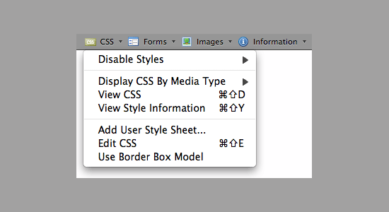
This extension comes with a toolbar that consisted handy set of menu options for almost all the debugging and inspecting facilities. There are some options like "View CSS information" which make it more and more beloved by the developers. it will show you the css information of the affected area of where you clicked on the web page. It has many other useful features, such as disable options for CSS, JavaScript and images, to test for degradation and progressive enhancement; a Forms menu with options for working with Web forms. This is an absolute essential add-on to any web developer/designer or anyone who is interested in seeing what any website looks like disassembled.


YSlow


               YSlow

This has been created by Yahoo! Developers. YSlow is a front end performance analyzer of a web page, and if its in a very poor stage YSlow will give you, a grade F and for converse situations a grade A. It gives you all the statistics about things such as the number of HTTP requests sent when someone request the page, summary of items that are loaded after requesting the page(eg: style sheets, java script file), etc. so that you can identify the bottlenecks that you need to over come for a faster loading page.

       There are many more Add-Ons that we can talk about. But we think, now we have built a considerable motivation for you to search more on this topic and explore things by your own. Before conclusion it is worth to draw your attention about the memory consumption in the browser when you use many add-ons. The more you add extensions,the more Firefox will  use  memory,and will prone to slow down your browser. Therefore it is important to use the best tool that has may features you need. (all in one)

Sunday, May 6, 2012

how do Add-ons work?

"Add ons" is a general term which comprises things such as plug-ins, extensions, and themes. You may have heard them related to web browsers as well as software applications.  For an example we often experience that "adobe flash player plugin is missing in this computer" like massages. plugins add specific abilities to larger software applications. Add ons are also called as ActiveX controls, browser helper objects or tool bars. some of them provide users , some interactive multimedia contents such as animations, music and ability to watch video contents. It will be useful to know how add-ons actually work with the main application. below is a  figure that simply explains it .


As you can see plugins can register themselves in the host application. for that it provides an interface to link with the host app. on the other hand host application also provides an interface to connect and exchange data with the plugin.(a kind of a protocol) Even though plugins add some extended functionality to the main application,they cannot function without having the services of the host app. Therefore at any time a user can disable the addon and use the general host app without any problem. some soft-wares provide an open API for developers to build useful extensions for their app.